I started looking at who I am and what makes me who I am. I looked at where I'm from. I went to the local studies library and sourced loads of old maps of where I'm from. I found maps of Turraheen from as far back as the 1840's. I took photos of the maps and printed them off. I took ordnance survey maps from my Dad of the land around home. I compared all the maps from when the British first started making maps of the area until present day maps. It was interesting to look at how the land has changed in that time and what has remained the same. I made acetate transparencies of all of the maps and layered them one onto the other to represent the changes.
 |
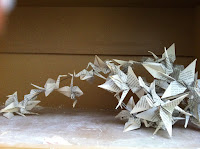
| ideas of what I could do with the paper maps-make 3d representations. I found this piece somewhere in the college and it gave me inspiration, |
 |
| Other ideas of what I could do with the maps |
I became interested in the typography of the maps and how it changed over time, the way the different map makers depicted the changes.
I also had an idea of how you could use the paper maps to make 3d representations, the idea of folding and manipulating the maps to make 3d representations.


No comments:
Post a Comment